- Home
- Top Sarawak Attractions
- Kubah National Park Hiking Trails
Kubah National Park Hiking Trails

Here you can find all you need to know about Kubah National Park Hiking Trails based on my experience.
Kubah National Park is a vast swathe of lush rainforest spanning 2,230 hectares surrounding Gunung Serapi and its neighbouring peaks. Being only 30 minutes drive from Kuching it is a popular place for day-tripping hiking enthusiasts, exercise addicts, nature lovers and bird watchers.
The Six Kubah National Park Hiking Trails

There are six trails within the park:
1. Mount Serapi Summit Trail

This is by far the most popular trail. When I went on a weekend it was very busy with hikers. Another time, on a weekday, there were few people around.
This trail is a tarmac road all the way to the summit viewpoint. The road is tarmac because it is used by Telecom Malaysia vehicles to reach their communications towers at the summit. Having said that, the road is almost completely traffic-free so you don't have to worry about cars.

Marker signs are placed every 500 feet so you can keep track of your progress. That's 500 feet of altitude, not distance. The summit viewpoint is 3,000 feet or 911 metres above sea level. The distance walked is 5km each way. The Park's map suggests it takes 3hours 30 minutes one-way but I think that is a bit generous. We took less than 5 hours to go up and down and our pace was by no means fast.
The distance, heat and relentless uphill climb makes it quite tiring but the walk is manageable for anyone with a reasonable level of fitness and the view at the top gives a worthwhile sense of achievement.

Nearing the summit we finally catch sight of the telecom tower which is a restricted area and off-limits.
Next to the viewpoint is an abandoned cabin. An entrepreneur could consider opening a food and drinks outlet here. It might do well!

A ropeway built to transport equipment up the telecom tower. Pity there is no cable car for passengers.

A viewing platform provides excellent views and an opportunity to rest and refresh before starting the long walk back down the hill.
The viewing platform is 911 m above sea level.
2. Waterfall Trail
This trail is 1600 metres and is supposed to take 1 hour 45 minutes (one way) but it can be done quicker if you do not hang about.

To get to the waterfall you first take the Mount Serapi Summit Trail for about 20 minutes then turn off to the right next to this shelter (the small white sign shows the way). Here you leave the tarmac road behind and follow a well-marked jungle trail.

The good thing about this trail is that it is mostly downhill to the waterfall. Of course, on the way back it is uphill but by then you will have got your breath back.

Trees are painted blue along the route so you know you are on the right path. There are even marker posts every 50 metres to keep you motivated.

Somebody clever once said 'If a tree falls in a forest and no one is around to hear it, does it make a sound?' I'm pretty sure there would have been a loud sound when this giant tree snapped!

Finally you will reach the waterfall. I took this photo in May and it hadn't rained for a few days so the flow was rather feeble. There were no other visitors here.

Waterfalls are dangerous with slippery rocks, sheer rock faces and surging water. Signs warn visitors about strong currents and flash floods and you are advised to leave the waterfall during heavy rain.
3. Rayu Trail

This jungle trail passes through the heart of the forest and ends at Matang Wildlife Centre. The distance is 3,830 metres and it takes about 3 hours (one way) from the Park headquarters according to their estimate. Of course once you reach Matang Wildlife Centre you either have to turn around and come back or have pre-arranged some transport to get you back to Kuching. I have not tried this trail yet but I will update this page once I get around to it.
4. Selang Trail
This is an offshoot of the Rayu Trail which takes you up to the Selang View Point. (1 Hour and 1,567 m).
5. Beccari Rattan Valley Trail
Another offshoot from the Rayu Trail which is 1,912 m and takes 1 hour 15 mins. Named after Italian botanist Odoardo Beccari.
6. Belian Trail
This is a shorter 45 minute trail (1,429 m) which starts next to the Park HQ but I have not tried this one yet.
Procedure for Registration & Check-In
Register
First of all, for all Sarawak National Parks, you need to register online through their official website.
You can both register and buy tickets online but what I do is just register only in advance (usually the day before) and then pay for tickets when I arrive at the park. In this way if the weather is terrible and you need to cancel you haven't wasted your ticket money.
Check In
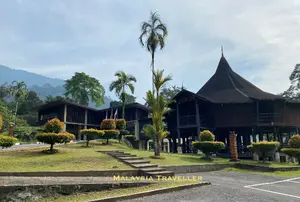
On arrival at Kubah National Park go to the Customer Service Booth pictured below and show your online registration QR confirmation and pay for your tickets (if you haven't already bought them online).
Tell the staff which trail you intend to take (so that they know where to start looking if you fail to check out!)

Check Out
When you have finished your hike you check out at the same office.
Opening Hours for Kubah National Park Hiking Trails
Park open from 8am to 5pm (weekdays)
and from 7:30am to 4:30pm (weekends and public holidays)
Latest time to enter the park is 11am and complete your hike and check out before 3pm.
Entrance Fee & Tickets
- RM10 for Malaysian adults, RM3 for children aged above 7 and below 18.
- RM20 for Foreigner adults, RM7 for children.

Accommodation
The park's accommodation is currently being redeveloped (as at June 2026). Upon completion overnight stays will be possible and Night Walks may be reintroduced to allow visitors to really appreciate all the park has to offer.
Kubah National Park Hiking Trails
Rules & Advice
- Cycling is not allowed.
- Drones are prohibited.
- Your bags might be checked by park officers upon check-in or check-out.
- Wear proper footwear (no open toe shoes) and protect yourself from the sun.
- Take plenty of water and stay hydrated.
- Stay on the marked trails.
- Avoid damaging the natural environment.
- Keep an eye on changing weather conditions.
- See my Mountain Climbing Tips for more useful advice.
Kubah National Park calls itself 'The Home of Palms and Frogs'
When it comes to frogs, a sign reminds visitors of 'Herping Ethics':
- Do not touch the frogs.
- Do not leave the trail or enter the frogs' breeding pool.
- Do not displace, move, transport or release frogs from one site to another.
These rules and regulations are backed up by the law with some hefty fines and penalties if caught.
You will pass a frog pond about 15 minutes into the Mount Serapi trail. It was mostly dried up during my visit and any frogs there were taking a siesta.
How To Get to Kubah National Park Hiking Trails
Kubah National Park is about 30 minutes drive away from Kuching Waterfront. The location of the Park HQ and entrance is shown on this map:
By Bus
BAS.MY bus number Q05 stops close to the Park entrance. See here for details.
By Car
There are a handful of parking places at the Park HQ, otherwise you can park on the side of Jalan Ke Puncak Serapi which is the approach road leading up to the Park. There is no charge for parking.
Nearby Attractions
You are unlikely to have the time or the energy to do anything else after climbing Gunung Serapi but since you are in the vicinity the following attractions are nearby:
- Home
- Top Sarawak Attractions
- Kubah National Park Hiking Trails
Share this page:
AUTHOR BIO

David (the one on the left) is the writer behind Malaysia Traveller, sharing first-hand travel advice from over five decades of living and travelling across Asia and the Middle East. Based in Malaysia since 2009 and now in Kuching, he has published over 790 pages on this website, personally visited every place he covers, and uses only his own photos. Readers can learn more on his About Me page. He also shares updates on Facebook and YouTube. He loves uncovering overlooked places that even some Malaysians have never visited.
Recent Articles


-
Gunung Gading National Park - Rafflesia, Waterfalls and Hiking
Sep 26, 26 11:26 PM
 Enjoy a hike at the pristine Gunung Gading National Park and maybe catch a glimpse of its star attraction, the rare Rafflesia flower in bloom.
 -
Bandar Seri Begawan Sightseeing Suggested 3 Day Itinerary
Sep 26, 26 04:58 AM
 With this suggested 3-day Bandar Seri Begawan Sightseeing Itinerary you will be able to cover all the main attractions in the Brunei capital.
 -
Sematan Beach and Sematan Village, Lundu, Sarawak
Sep 03, 26 11:16 PM
 Sematan Beach and Sematan Village is an attractive coastal area within easy reach of Kuching. Here is what you can expect.



Getting Around
- Free KL City Bus
- KL Hop-On Hop-Off
- BAS.MY Kuching
- BRT Sunway Line
- Malaysia By Coach
- Malaysia By Train
- Pangkor Ferry
- Marina Island Ferry
- Penang to Langkawi Ferry
- Visa Requirements
Hotels
- Pet Friendly Hotels
- Majestic Hotel KL
- Hotels in Melaka
- Hotels in Penang
- Hotels in Putrajaya
- Port Dickson Resorts
Great Malaysian Railway Journeys

CONTACT ME | PRIVACY POLICY | TRAVEL BLOG
Trusted By Over 13 Million Unique Visitors Since 2011. Over 36 Million Page Visits. Statistics up to end September 2026.